Final Essay
- 31 October 2025
A Muddied Land
Jo Dalgety
6942 MFA Part Four: Final Essay
PDF VERSION

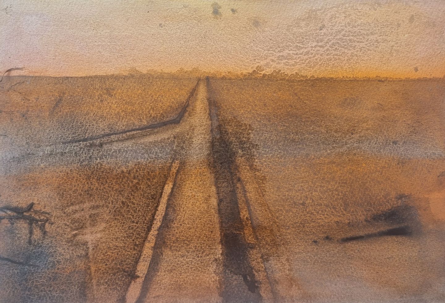
Figure 1. Jo Dalgety, Winning 90,000 Acres from Sea and Swamp, river mud and watercolour on paper, 2024
Within my practice as a painter I have been expanding my range of materials through integrating natural elements such as river mud and water, alongside referencing historical photographs and the traditions of watercolour to interrogate and destabilise the established conventions and idealised representations that underpin the Western landscape painting tradition.
Through contemporary re-engagement with the landscape of the Hauraki Plains I have been challenging inherited pictorial traditions while aiming to reveal the ecological and historical complexities that lie beneath pastoral imagery. Landscape painting becomes not merely a depiction of scenery but an act of inquiry - one that exposes the layered histories of land use, loss, and adaptation, and reconsiders how belonging and responsibility are visually expressed.
 |
 |
|
Figure 2. Jo Dalgety, A portion of the rich farmlands on the Hauraki Plains, watercolour & river mud on paper, 2025. |
Figure 3. Jo Dalgety, How a Modern Dredge Operates, watercolour & river mud on paper, 2025. |
I reference historical photographs, often in black and white or sepia, remaining conscious of the way such images can soften or romanticise history. To counter that I have experimented by using somewhat unnatural colours to deliberately draw attention to human intervention within the wetlands, as in figure 2. These colours appear artificial or slightly off, serving as a visual signal that something within the landscape is disturbed or not as it should be.
Watercolour is a loaded medium, tied to colonial botanical and topographical traditions. Given the wetland site I am working in, watercolour feels the relevant medium to use. Over time I have extended the possibilities of this medium, developing both material and conceptual connections to water and the wetland environment, as is evident in figure 3. Watercolour behaves according to its own natural laws, functioning as a collaborator rather than a controlled tool. I allow the pigment to bloom, puddle, seep, and collapse - processes that evoke contamination, seepage, and the broader themes of ecological degradation central to the practice.
I incorporate mud and water collected from the Piako River, materials often chemically compromised by agricultural runoff. Figure 5 shows flecks of orange colour in the mud; presumably contaminants. These locally sourced elements physically embed the land’s history into each work, carrying traces of both natural processes and human intervention. The act of using unstable impermanent materials draws attention to the ongoing vulnerability of the wetland ecosystem, highlighting how environmental change and degradation become part of the artwork itself.
 |
 |
|
Figure 4. Jo Dalgety, A Digger Type Dredge Working on the Hauraki Plains, river mud and watercolour on paper, 2024. |
Figure 5. Jo Dalgety, A Wonder-waking Project, river mud and watercolour on paper, 2025. |
In the painting process the paper is first soaked in mud and left to dry. The resulting surface is unpredictable, and its texture and tone determine compositional decisions such as the placement of subject matter. Watercolour is then used to introduce subject matter traced from found photographs. This process requires a negotiation between the potentially overwhelming material presence of the mud, and the intention to retain some presence of the photographic referent. As with traditional watercolour practice, failure is an inherent part of the process, but incorporating mud heightens this instability. There is no possibility of correction or ‘fixing’ the image, only acceptance of what the materials yield. The drying process becomes an active participant in the development of the work, as the water evaporates from the surface, the paintings continue to evolve.
These paintings are deliberately archivally unstable; they may not endure. In this way the materials themselves resist permanence, embodying an ecological fragility. The resulting works are unstable both materially and conceptually: materially, because they are not designed to last as artefacts; and conceptually, because they consciously seek to unsettle mythologies of land health, and the enduring positive narratives of progress and improvement that underpin colonial landscape traditions in Aotearoa.
I have begun stabilising the mud and watercolour materials with a coating of wax medium, a process that parallels the photographic stop bath, which neutralises the developing agent, and halts further chemical change. While the wax prevents the surface mud from drying and flaking, thus retaining the image, the leaching of chemicals within the paper itself can continue, reinforcing the work’s non-archival nature. In this context the wax functions as an inhibitor suspending further transformation of the surface while the paper remains in a state of continual flux.
In Aotearoa landscape painting has been instrumental in constructing and reinforcing perceptions of place. The visual traditions introduced by European painters frequently perpetuated colonial narratives that framed the land as vacant, untamed, or awaiting cultivation, effectively erasing the complex relationships Māori maintained with their ancestral environment. Picturesque imagery played a strategic role in colonial enterprise with the New Zealand Company employing these types of paintings to attract prospective European settlers. Ecologist Geoff Park observed that “New Zealanders have a particular thing about picturesque scenery; it has probably more than a little to do with its persistence in our brief history.”[1] This enduring visual tradition remains embedded in contemporary tourism, idealising the landscape of Aotearoa as an untouched and unspoiled paradise.
The focus of the practice is on the Hauraki Plains in Piako, previously home to a vast kahikatea forest that has now completely disappeared. Once the country’s largest wetland, the Piako area held immense significance for Māori who valued it as a source of food and resource; a highly productive, carefully managed taonga. Indigenous people recognise the deep intrinsic connection between people, whenua (land), and the natural world. European settlers viewed wetlands as swamps, and their stagnant water systems as wastelands, largely due to the belief that they harboured toxic miasma and bred disease. This perception, transported from Europe, fuelled the drive to drain and transform New Zealand’s landscapes.[2]
This body of work is grounded in an awareness of the loss and devastation inflicted on land, flora, fauna, and human communities when decisions are driven solely by profit, and the consequences of choices made without consideration to long-term ecological or social impacts, where financial gain eclipses respect for the natural world.
 |
|
Figure 6. Research image of the Hauraki Plains from Back Miranda Road, November 2024. (Photograph by the author). |
Park observed of the Hauraki Plains that “the recognisable combination of trees, pasture and human structures makes it seem perhaps as if they are all that was there.”[3] That struck me deeply, because I didn’t know what was there before.
Growing up on the Hauraki Plains, I was never told - nor did I ever ask - what existed before dairy farming. I was shocked, not only by the scale of what had been lost, but by how little I knew. Drainage and mud and cattle - those were constants in our lives. I never questioned the deeper history of this place, or the people.
Donna Haraway a prominent scholar in the field of science and technology, reminds us that planetary change has always been shaped by forces beyond humans; seed-dispersing plants, for example, reshaped Earth long before agriculture.[4] The Piako was a land transformed by ecological upheaval after the Taupo eruption 20,000 years ago. Natural forces of sedimentation and erosion redirected the Waikato River, which once flowed through the Piako to the Hauraki Gulf, to its current path into the Tasman Sea. This created the Piako and Waihou Rivers, shaping the wetland’s unique ecology.[5] It was into this transformed environment that Polynesian navigators, and later, European settlers arrived.
Haraway acknowledges the complex entanglements in which both organic species and abiotic elements co-produce planetary change. Her perspective emphasises multispecies, and more-than-human assemblages, where agency and responsibility are distributed across a network of human and nonhuman actors.
No species, not even our own arrogant one pretending to be good individuals in so-called modern Western scripts, acts alone; assemblages of organic species and of abiotic actors make history, the evolutionary kind and other kinds too.[6]
Haraway describes abiotic actors as other-than-human entities, physical but non-living forces such as minerals, weather systems, or geological formations. She says that while not alive in a biological sense, they are neither inert nor sterile; they actively participate in shaping ecological and material realities. Haraway describes their relationship with human-facilitated phenomena as not merely one of passive interaction but of ‘intra-action,’ which highlights the mutually constitutive nature of relationships.[7] In this view, abiotic and biotic agents do not exist independently and then interact; instead, they emerge through their entanglements with each other, co-producing the conditions of existence.
In 1769, while on his first visit to New Zealand, Captain James Cook travelled inland up the Waihou River, and oblivious to the fact it already had a name, he renamed it The Thames.[8] Captain Cook and the botanist Joseph Banks were struck by what they saw. Banks described swamps that “might doubtless easily be drained,” and their soils rich and fertile, and timber trees “the largest I have ever seen.”[9] Figure 7 depicts a kahikatea forest located on the West Coast of the South Island, offering a visual impression of the landscape that Captain Cook and Banks would have encountered as they travelled up the Waihou River.
 |
|
Figure 7. Craig Potton, Author Geoff Park at Kahurangi National Park in best-pressed colonial linen suit, 1995, Ngā Uruora, accessed October 22, 2025, https://www.ngauruora.nz/. |
European explorers and colonists often failed to acknowledge indigenous land use, adhering to the doctrine of terra nullius (land belonging to no one). This international law allowed European nations to claim land by right of discovery. As Park states in his book, Theatre Country: “‘wild,’ ‘wilderness,’ ‘waste’ was how they labelled any land to which their eyes didn’t observe close settlement and well-tended cultivation, or any land that wasn’t occupied by people evidently of their equal.”[10] On Captain Cook and Banks’ journey up the Waihou River they decided “they were in an empty landscape.”[11] In Captain Cook’s journal he wrote: “we saw only a few small places that were cultivated.”[12] Observation was key; a 1980s survey of the vicinity of Cook’s voyage located almost 100 kāinga sites on the Waihou River’s eastern flank alone.[13]
This mindset justified both the conquest and appropriation of Māori land; as Park has commented: “Ecologically, these were landscapes of interconnection and interaction, the antithesis of the boundary lines and the grid subdivision of the country into legally separated units desired by English land laws."[14]
At the time when I began uncovering the history of the Piako region I learned that a friend was researching the history of his iwi, Ngāti Paoa, whose traditional territories extend from the Hauraki Plains up to the eastern suburbs of Auckland, and the islands of the Hauraki Gulf. In the words of Arnold Gurau from Ngāti Paoa: Paoa ki tua o Matariki, Paoa beyond Pleiades.[15]
This shared interest has led to a collaborative research relationship that continues today, enabling a deeper understanding of the social and cultural impact of appropriation of land, and destruction of resources experienced by Ngāti Paoa. This has provided insight into how similar processes of dispossession, and ecological transformation may have affected other Hauraki iwi who lived on the edges of the Piako wetlands, such as Ngāti Maru and Ngāti Hako.
Ngāti Paoa have generously provided guidance and support for my practice, particularly concerning the respectful collection, use, and return of whenua. Initially, gathering and using whenua and water from the Piako River caused me discomfort, even in small quantities the act risked echoing the extractive behaviours of settlers, including my own ancestors. The counsel offered by Ngāti Paoa helped me to proceed with care: to pause before beginning, ensuring that my heart and mind are aligned and that ego is set aside. As part of my process, all remaining material and water are returned to their original site of collection following the same principles of respect and reciprocity.[16]
The wetlands of the Piako were once abundant with rushes, reeds, flax, and towering kahikatea. When the kahikatea fruited the forests came alive - birds filled the canopy, people gathered. Beneath their roots, eels and mudfish hibernated through dry summers, a delicacy for feasts. This richness - all of it - was lost under Crown law as the wetlands were drained, as Banks had suggested. Settlement began in earnest just seventy years later.
For the new colony intent on rapid development this landscape became a showcase to generate wealth, while also revealing the heavy cost such progress exacted on natural systems and habitats. The new English-based government celebrated this as progress. While the drainage of the Hauraki Plains wetlands resulted in the loss of traditional Māori food sources, and ecological systems, it also facilitated the establishment of an intensive agricultural economy. With the introduction of refrigeration technology this newly created farmland enabled the export of dairy and meat products, generating significant economic benefits for European settlers; advantages that continue to underpin New Zealand’s export economy today.[17]
Figure 8 shows the first cattle sale there, and both of my great-grandfathers captured in this image had been allocated neighbouring farms in the first land ballot.
 |
|
Figure 8. A Sure Sign of Progress. The first cattle sale on the Hauraki Plains, Thames District, Auckland, Auckland Weekly News 2/05/1912, Auckland Libraries Heritage Collections, accessed October 22, 2025, https://kura.aucklandlibraries.govt.nz/digital/collection/photos/id/207417/rec/12. |
Similar to Captain Cook and his cohorts the Dalgety family lent their name to a road, and a corner in their new home on the Hauraki Plains. My great-grandparents had immigrated from Britain hoping for a better life for their large families; they continued to clear the land, and create farms, and we grew up proud of that hard work.
 |
|
|
Figure 9. Research image, Dalgety Road, 2024. (Photograph by author). |
How do I acknowledge my Pākehā family’s role with care? On one hand, I want to tell the story of ecological devastation. On the other, I need to honour my family’s search for a better life. These narratives, like all living and non-living entities, are inseparably intertwined. Revealing the layers of relationship, memory, and history within the Hauraki Plains feels essential to end the forgetting.
Within decades of European discovery the ‘noble’ kahikatea had vanished, and drainage was well underway. Government policies led to an eight-five percent loss of Aotearoa’s wetlands, the most severe decline of its kind in the world.[18] This large-scale destruction has resulted in profound social and ecological consequences, many of which are difficult, if not impossible, to reverse. Environmental transformation often becomes invisible, forgotten, and normalised. Forgetting can serve as a tool of power, and erasing the past helps preserve the status quo, and allows dominant narratives to remain unchallenged.
Writer, historian, and activist Rebecca Solnit explores how societies remember, or deliberately forget events marked by violence, injustice, and trauma. She contends that memory is inherently political, not merely personal, and is often constructed by those in positions of power.[19] The choices societies make about what to commemorate and what to erase reflect the interests and influence of dominant narratives. Sudden acts of destruction capture immediate attention and are often etched into collective memory, while slow-moving crises like global warming may ultimately cause far greater harm. Solnit contrasts the widely remembered spectacle of the planes crashing into the World Trade Centre with the largely forgotten, gradual devastation of the South Bronx through waves of small, deliberately lit fires during the 1970s and 1980s.[20] As Solnit writes: “Ruins represent the physical decay of what preceded them, but their removal erases meaning and memory.”[21]
Today the Hauraki Plains are comprised of farmland and small rural towns - few clues remain of the ancient forest that once stood. Park saw “history’s invisible violence in the Hauraki Plains’ monotonous geometry of long straights, stop banks and shelterbelts.”[22] Park uses American ecologist Daniel Janzen’s words: “what escapes the eye is the most insidious kind of extinction – the extinction of interactions.”[23] Park expands on this for us:
The ecological effect of swamp drainage in New Zealand was as though a major organ like the heart had been ruptured and removed. When the native birds no longer had the premier breeding and feeding zones that the lowland swamps provided, the hill forests, too, went silent.[24]
The name Piako means ‘the emptying waters.’[25] Piako is the wetlands area from the base of the Hauraki Gulf to Matamata. Early settlers began to refer to the region as the Piako Swamp, and to distance the area from the negative connotations associated with the term swamp, the land directly below the Hauraki Gulf was renamed the Hauraki Plains, reinforcing the notion of flat, productive farming land.[26] Natural history author Jane Hunt explains: “’Swamp’ was not exactly a favourite word: they intended to replace it with ‘paddock’ and that, in time, is what they did.”[27] Wealth, and the pursuit of it, typically leads to the removal of existing structures and communities, replacing them with more profitable modern versions that erase what once was. Solnit writes: “Memory is often the spoils of the defeated, and amnesia may sometimes be the price of victory.”[28]
Paul Monin, New Zealand historian and author, known for his work on the history of the Hauraki region wrote: “The Māori past of Hauraki is virtually non-existent in the popular memory and scarcely discernible in the landscape. This is a region of New Zealand where the triumph of European settlement has been overwhelming.”[29] A 1910 newspaper article summed up European pride: “Man’s conquest over nature was probably never more active… In the transformation of the Piako, there are all the elements of a romance of modern times.”[30]
The captions from the historical news items and photographs I reference have become part of the practice; using titling such as Drainage by modern methods, A Romance of Our Times and A Sure Sign of Progress – see figures 10 and 11. These captions sound congratulatory and feel uncomfortable, sometimes cringeworthy. Reusing them as titles for my paintings embeds the captions within the work, sharpening the sense of disjunction. They invite the viewer to question the story they tell, and to sit with the discomfort of history.
 |
|
Figure 10. Drainage by Modern Methods in the Hauraki Plains District the Latest 45-h.p. Caterpillar Dredge at Work, Deepening the Piako River., Auckland Libraries Heritage Collections, accessed October 20, 2024, https://kura.aucklandlibraries.govt.nz/digital/collection/ photos/id/239141/rec/37. |
 |
|
Figure 11. Jo Dalgety, Drainage by Modern Methods on the Hauraki Plains, watercolour on butter paper, 2024. |
The drained land is not without complications. While the peat-based soils are initially fertile, they require substantial inputs of lime, phosphorus, potassium, and sulphur to sustain productive pasture growth. These soils are also prone to drying out during summer months, creating further challenges for farming.[31] These conditions raise broader questions: how much strain can natural systems bear before they collapse? And at what point does development exceed the limits of ecological resilience?
Haraway draws on anthropologist Anna Tsing’s concept of refugia, pockets of ecological and cultural resilience, as critical to understanding the gravity of our current moment. Tsing suggests that the true inflection point may not simply be widespread destruction, but rather the elimination of these refugia: the remaining spaces from which multispecies assemblages might re-emerge and reconstitute themselves after catastrophic events. “Anna Tsing argues that the Holocene was the long period when refugia, places of refuge, still existed, even abounded, to sustain reworlding in rich cultural and biological diversity.”[32] The transformation of the Piako area has been so extensive that reversing it seems impossible. Park states that “without the fruit dispersers and pollinators, more far-reaching ecological processes switch off.”[33]
Haraway argues that we are confronting “extraordinary burdens of toxic chemistry, mining, depletion of lakes and rivers under and above ground, ecosystem simplification, and vast genocides of people and other critters.”[34] These interlinked processes, driven by capitalism and domination, are accelerating towards potential ecological, social, and geological collapse from which recovery may no longer be possible. Tsing suggests the true crisis may be the elimination of refugia - those last places from which life might re-emerge after catastrophe.[35]
Artist Anselm Kiefer‘s birth at the end of World War II placed him in a Germany still recovering from the war. His art was profoundly shaped by the ruins, trauma, and national silence surrounding the Nazi era, from which he pursued a practice based in honesty and confrontation.[36]
 |
|
Figure 12. Anselm Keifer, Brennstäbe (Fuel Rods), 1984–87, oil, acrylic, emulsion, and shellac on canvas with ceramic, iron, copper wire, straw, and lead, Saint Louis Art Museum, accessed October 7, 2025, https://www.slam.org/press-room/press-releases/saint-louis-art-museum-to-present-major-exhibition-of-anselm-kiefers-work-in-fall-2025/. |
German Romantic painting had engaged with themes of the sublime in nature, folklore and myth, nationalism, and individual sensibility.”[37] Kiefer, however, regarded Germany’s mythologies and nationalist narratives as profoundly problematic. In contrast to the Romantic celebration of these traditions, his work sought to embody the destructive forces of history, and he came to conceive of painting as a form of violent historical re-enactment.[38] Rather than embracing the abstraction emerging from America, he turned instead to German Expressionism - seeking raw texture and the gritty materiality of historical truth. Schama tells us that “Keifer had more weighty things on his mind ... And to express those things, he needed a reinvention of traditional forms; above all, landscape and history painting."[39] His paintings did not merely depict the aftermath of devastation - they performed it, consuming and transforming the landscape through the very materials and gestures of their making. The materials that Kiefer uses in his paintings – straw, earth, sticks – may fall off in transport, while shifting, when hanging, and with time. For Keifer, destruction became part of his expression, forcing us to look at history, myth, icons, memory, and materiality, not with comfort, but with discomfort. [40] In his work forgetting is not an option. He deliberately unsettles the viewer - provoking us to remember. To quote Kiefer: “If we don’t remember what we have done, we will do the same thing again.”[41]
 |
|
Figure 13. Kate van der Drift, Waning Gibbous to Waxing Gibbous, September 2020 I, 37°17’41.6”S 175°31’35.7"E, 2023 Chromogenic Photograph from 4x5” Negative 1423 x 1100 mm, Kate van der Drift, accessed October 22, 2025, https://www.katevanderdrift.com/listening-to-a-wet-land. |
Artist Kate van der Drift is a contemporary photographer based in Aotearoa whose practice is grounded in an “engagement with ecological processes, human relationships to place, and the potential of photography as a mode of attentive listening and collaborative storytelling.”[42] She makes camera-less ‘river exposures;’ when images are formed while being “exposed to water in the absence of daylight by submerging film in lightproof holders in the Piako awa’s tributaries”.[43] This process is part of her ongoing investigation into the ecological complexities of the waters and landscape of the Hauraki Plains. Once immersed in the water the emulsion on the negative is gradually eroded by a combination of agricultural run-off, saltwater, sediment, bacteria, and algae. In van der Drift’s practice, the emphasis is on cultivating care for the land; her project focuses on the Hauraki Plains by examining the ecological degradation of waterways resulting from agricultural run-off, while acknowledging the entangled social and ecological histories.[44]
I am interested in the ways van der Drift’s practice also engages with the Hauraki/Piako region, addressing the degraded state of its waterways, and employing water itself as an active material agent; paralleling my own use of river mud. However, our approaches diverge in their visual outcomes. Many of van der Drift’s works move toward abstraction, producing compositions that are strikingly beautiful (as seen in fig. 13). In contrast, my work retains the structural conventions of historical landscape imagery - foreground, horizon, and sky - to critically engage with the colonial history of landscape representation, and its role in shaping perceptions of land during, and after colonisation.
 |
|
Figure 14. William Hodges, Cascade Cove, Dusky Sound, 1775, Royal Museums Greenwich, accessed October 22, 2025, https://www.rmg.co.uk/collections/objects/rmgc-object-13847. |
 |
|
Figure 15. Mark Adams, After William Hodges' 'Cascade Cove' 21 May 1995, gelatin-silver prints, toned, Auckland Art Gallery Toi o Tāmaki, accessed October 22, 2025, https://www.aucklandartgallery.com/article/mark-adams. |
Aotearoa artist and photographer Mark Adams carefully portrays culturally significant sites, inviting us to re-examine landscapes often loaded with meaning. Adams retraced the voyage of Captain Cook and the artist William Hodges, capturing the landscape's lingering presence of these historical encounters. Figure 15 shows After William Hodges 'Cascade Cove,’ a four-part photographic work from his series Cook's Sites.
Adams explains that he likes to reverse the colonial gaze, exposing the complications of representation. He reminds us that what appears to be a simple surface view of the land is never neutral.[45] A landscape only starts to speak its truth when the layers of relationship, memory, and history are uncovered.
Australian anthropologist Nicholas Thomas, who has known Adams since 1993, wrote in the afterword to Mark Adams: A Survey, the catalogue that accompanied the 2025 exhibition at Auckland Art Gallery:
All of Mark Adams' work has amounted to that other kind of witnessing, a witnessing of context, a witnessing of what has been taken away, hidden or forgotten, as well as what can be seen there, that was always there, or has just been introduced.[46]
 |
|
Figure 16. Mark Adams, Site of Hinemihi, Te Wairoa The Buried Village, C type prints from 10 x 8-inch C41 negatives 1275 x 3060 mm, 11.5.2000, Two Rooms, accessed October 22, 2025, https://tworooms.co.nz/exhibitions/hinemihi-te-hokinga-mai-the-return/. |
 |
|
Figure 17. Mark Adams, Hinemihi, Clandon Park, Surrey, England Nga Toanga: Wero Taroi, Tene Waitere, 13.11.2000, Two Rooms, accessed October 22, 2025, https://tworooms.co.nz/exhibitions/hinemihi-te-hokinga-mai-the-return/. |
Hinemihi was constructed in early 1881 at the village of Te Wairoa, near the famed Pink and White Terraces, and survived the 1886 eruption of Mt Tarawera. Toward the end of his tenure as Governor of New Zealand, William Hillier, the 4th Earl of Onslow, sought to take a memento of the country he had come to admire. Consequently, Hinemihi was purchased and relocated to Clandon Park in Surrey, England.[47] Adams’ photographs capture both what has been lost, and what is yet to come - after more than 130 years away Hinemihi is finally returning home.
Captain Cook’s words about “the banks of the Thames” as “the best place for a colony” were the first used by Edward Gibbon Wakefield to promote his master plan for New Zealand settlement.[48] The Wakefield settlement model promoted New Zealand as a land of promise, yet the fertile plains settlers expected, still unseen by Wakefield, were often vast wetlands. Flat land that was attractive to prospective settlers was at a premium.
John Locke was the intellectual forefather of the waste lands concept. One of the first philosophers of the Enlightenment, and the father of classical liberalism with its focus on individualism and property rights, Locke's ideas underpinned Wakefield's thinking.[49] To promote immigration to their New Zealand Company settlements, the book Adventure in New Zealand was illustrated with engravings that presented the settlements in an attractive light, with flattish land and prosperous activity like cattle and sheep.[50]
 |
|
Figure 18. Charles Heaphy, Mount Egmont from the Southward, watercolour, September 1840, National Library Wellington, accessed October 22, 2025, https://natlib.govt.nz/records/23173901. |
Charles Heaphy, a draughtsman for the New Zealand Company, painted Mount Egmont from the Southward (see fig. 18) elongating the mountain for beauty, and framing it with delicate trees, while showing flat cleared land ready for settlement.[51] Picturesque. Empty. Waiting. Park explains about Heaphy’s promotional paintings: “However he actually depicted the swampy kahikatea and flax country … it appeared in the Company’s promotional lithographs as sprawling, well-drained, well-wooded open plains country.”[52]
This raised the question: how can I represent the ecological and social consequences of destruction? The Hauraki Plains as they appear today are lush, green, and fertile. The rivers glisten, the trees line the fields. To many viewers it looks idyllic - an agricultural success story (see fig. 19), but this romantic illusion masks the destruction that made it possible.
 |
|
Figure 19. Jo Dalgety, Untitled Study of Hauraki Plains, watercolour on paper, 2024. |
On the other hand, to reimagine the ancient kahikatea forest also carries its own risks (see fig. 20). There is a danger of creating an idealised vision of what was lost. This tension - between ecological destruction and romanticising the past - is one I continue to work with. How do I depict both ecological loss and devastation, and the social impact on people, without slipping into nostalgia? Translating this history through the lens of my Pākehā family is complex. They arrived in search of a better life, yet their settlement also contributed to the transformation and erasure of what was already here.
 |
|
Figure 20. Jo Dalgety, Untitled Study, watercolour on paper, 2024. |
Another approach I have explored is painting on butter paper using historical, and family photographs as source material (see fig. 21). Butter paper has its own significance: the kahikatea forests that were felled were used to make butter boxes, transporting New Zealand dairy products around the world. Butter paper becomes a stand-in for the loss of the kahikatea. It is fragile, impermanent, and materially connected to this history.
 |
|
Figure 21. Jo Dalgety, Various titles, watercolour on butter paper, 2024. |
This type of transparent paper has also offered a practical means of tracing elements from photographs in order to transfer them onto paintings. When experimenting with larger-scale paintings on watercolour paper, the process of enlargement seemed to diminish the character and intensity of the original photographs. Consequently, I have come to prefer working on a smaller scale, maintaining a one-to-one scale relationship with the photographic referent.
 |
|
Figure 22. THE GREAT PIAKO SWAMP, NOW BEING RECLAIMED BY THE NEW ZEALAND GOVERNMENT, Auckland Weekly News, 1908-10-22, Auckland Libraries Heritage Collections, accessed October 22, 2025, https://kura.aucklandlibraries.govt.nz/digital/collection/photos/id/184333/rec/2 |
In my paintings I often accentuate the empty flat horizon, drawing primarily from the reference photograph shown in figure 22. This stark horizon has become a recurring motif within the practice, serving as a visual device through which to underscore narratives of loss (see fig. 23). Central to the practice is a deep concern about the future: how we might make choices that honour the wholeness of ecological systems, beyond human interests alone. The calculation of natural cost against commercial benefit is a precarious balancing act.
 |
|
Figure 23. Jo Dalgety, An Important Undertaking, Piako river mud, charcoal, watercolour on paper, 2025. |
Haraway highlights the cultural, spiritual, and ecological ties that bind human and non-human life, calling for ways of thinking and living that honour these connections in the face of planetary crisis. She acknowledges the profound scale of ongoing loss: “there are so many losses already, and there will be many more.”[53] In response, Haraway calls for collective action and responsibility, insisting on the urgent need to cultivate and preserve refugia, places of shelter and resilience, from which multispecies assemblages might re-emerge and reconfigure. She warns that irreversible destruction is already underway, impacting millions of human lives as well as countless other-than-human beings, and presses us to act in solidarity to support the possibility of ongoingness for all life.[54]
Recent government decisions in Aotearoa have increasingly prioritised economic growth over environmental protection. Policies enabling easier business operations within conservation zones, the introduction of the Fast Track Bill that subordinates wildlife to development interests, and provisions allowing corporations to sue the government for implementing environmental safeguards collectively reflect a shift towards deregulation, and the erosion of ecological responsibility.
As Haraway urges in Staying with the Trouble - we must ‘make kin,’ expanding our sense of care beyond ourselves, politically, ecologically, and ethically.[55] Haraway contends that all earthlings are kin and asserts that it is long overdue to cultivate more responsible and compassionate care, not as isolated species, but as interconnected assemblages.
This practice engages critically with the interconnections between materiality, ecology, and the colonial histories embedded within the Hauraki Plains. Through the incorporation of natural elements such as river mud and water, alongside historical photographs and traditional watercolour, the work interrogates the conventions of Western landscape painting and its idealised representations of the picturesque. The instability of these materials, chemically, physically, and conceptually, functions as a metaphor for ecological fragility as a means of resisting narratives of permanence and progress that have historically shaped settler-colonial relationships with the land. Informed by dialogue with Ngāti Paoa, and grounded in principles of respect, reciprocity, and responsibility, this practice repositions painting as a site of ethical engagement with place. By foregrounding processes of transformation and decay, the work reimagines the landscape not as a fixed image or commodity, but as a dynamic, living system; one that continues to bear the traces of human action and the potential for renewed forms of care.
Bibliography
Denyer, Karen, and Monica Peters. Life in the Shallows: The Wetlands of Aotearoa New Zealand. Massey University Press, 2022.
Enjoy Gallery. “All This Work Is Necessary.” Accessed 14/10/2025. https://enjoy.org.nz/all-this-work-is-necessary
Farrar, Sarah. “About Time: The Photography of Mark Adams.” ArtToi, April 2025.
Haraway, Donna. “Anthropocene, Capitalocene, Plantationocene, Chthulucene: Making Kin,” Environmental Humanities 6, no. 1 (May 1, 2015): 159–65. https://doi.org/10.1215/22011919-3615934.
Haraway, Donna. Staying with the Trouble: Making Kin in the Chthulucene. London: Duke University Press, 2016.
Hatvany, Matthew. “Environmental Failure, Success and Sustainable Development: The Hauraki Plains Wetlands Through Four Generations of New Zealanders.” Environment and History 14, no. 4, Trans-Tasman Forest History special issue (Nov., 2008): 469–95. doi:10.3197/096734008X368402.
Hawke, Gary. “Economic thought – Wakefield and the economics of colonies,” Te Ara – the Encyclopedia of New Zealand, https://teara.govt.nz/en/artwork/22293/new-zealand-company-propaganda (accessed 28 October 2025).
Hill, Carolyn, ed. Kia Whakanuia Te Whenua: People, Place, Landscape. With Waiari MacMillan. Mary Egan Publishing, 2021.
Honour, Hugh. Romanticism. London: Penguin Books Ltd, 1979.
Hunt, Janet. Wetlands of New Zealand. Auckland: Random House, 2007.
Judd, Warren. “Natural Values,” NZ GEO, ISSUE 133 May - Jun 2015 https://www.nzgeo.com/stories/natural-values/ (Accessed 30 October 2025).
McLeod, Isabel. “Some memories of my life at Maramarua, Pipiroa and Ngatea”. Ngatea [N.Z.]. Recorded and documented 28 July 1997.
Monin, Paul. This is My Place, Hauraki Contested. Wellington: Bridget Williams Books, 2001.
New Zealand Graphic. “Transforming the Piako.” Issue 6. February 9, 1910. Volume XLIV Edition. https://paperspast.natlib.govt.nz/periodicals/NZGRAP19100209.2.35.
Ohinemuri Regional History Journal 55, September 2011 (Reprinted from the Hauraki Plains Gazette, October 1, 1951.) Accessed 25 August 2025.
https://www.ohinemuri.org.nz/journals/journal-55-september-2011/from-swamp-to-farm-land
Park, Geoff. Ngā Uruora. Wellington: Victoria University Press, 1995.
Park, Geoff. Theatre Country: Essays on Landscape and Whenua. Wellington: Victoria University Press, 2006.
Sanderson Gallery. “Kate Van Der Drift.” Accessed October 7, 2025. https://sanderson.co.nz/artists/29-kate-van-der-drift/overview/.
Schama, Simon. Landscape and Memory. New York: Alfred A. Knopf, 1995.
Schmidt, Tyson. "a few patches of potato-ground and rude dwelling places." in views of New Zealand through Lockean eyes, AHA: Architectural History Aotearoa (2012) vol 9:67-79.
Solnit, Rebecca. Storming the Gates of Paradise: Landscapes for Politics. California: University of California Press, 2008.
Sturgis, Xa. “ANSELM KIEFER AND THE ARTIST’S ROLE.” Accessed 15/10/2025. https://www.ashmolean.org/article/anselm-kiefer-and-the-artists-role-confronting-the-past
Tsing, Anna. “Feral Biologies,” paper for Anthropological Visions of Sustainable Futures, University College London, February 2015.
Tūroa, Taimoana. Te Takoto o Te Whenua o Hauraki = Hauraki Landmarks. Auckland: Reed, 2000.
Two Rooms. “Mark Adams.” Accessed October 30, 2025. https://tworooms.co.nz/exhibitions/mark-adams-2/
Tye, Rufus Edward. “Hauraki Plains Story.” Thames Valley News, 1974.
Van der Drift, Kate. “Listening to a Wetland.” Accessed October 22, 2025. https://www.katevanderdrift.com/listening-to-a-wet-land
[1] Geoff Park, “Theatre Country,” in Theatre Country: Essays on Landscape and Whenua (Wellington: Victoria University Press, 2006), 115.
[2] Geoff Park, “Swamps which might doubtless easily be drained,” in Theatre Country: Essays on Landscape and Whenua (Wellington: Victoria University Press, 2006), 187.
[3] Park, “Swamps which might doubtless easily be drained,” 180.
[4] Donna Haraway, Staying with the Trouble: Making Kin in the Chthulucene (London: Duke University Press, 2016), 99.
[5] Geoff Park, “The Immense Trees of Ooahaouragee,” in Ngā Uruora (Wellington: Victoria University Press, 1995), 47.
[6] Donna Haraway, “Anthropocene, Capitalocene, Plantationocene, Chthulucene: Making Kin,” Environmental Humanities 6, no. 1 (May 1, 2015): 159–65. https://doi.org/10.1215/22011919-3615934, 159.
[7] Intra-action is a concept given us by Karen Barad, Meeting the Universe Halfway (Durham, NC: Duke University Press, 2007), quoted in Haraway, Anthropocene, Capitalocene, Plantationocene, Chthulucene: Making Kin, 159.
[8] Park, “Swamps which might doubtless easily be drained,” 180.
[9] Ibid.
[10] Geoff Park, “Our Terra Nullius,” in Theatre Country: Essays on Landscape and Whenua (Wellington: Victoria University Press, 2006), 166.
[13] Ibid., 62.
[14] Park, “Swamps which might doubtless easily be drained,” 189.
[15] Arnold Gurau, Ngāti Paoa, Personal meeting with the author at their studio, March 2025.
[16] Arnold Gurau, Ngāti Paoa, Email message to the author, October 21, 2025.
[17] Matthew Hatvany, “Environmental Failure, Success and Sustainable Development: The Hauraki Plains Wetlands Through Four Generations of New Zealanders.” Environment and History 14, no. 4, Trans-Tasman Forest History special issue (Nov., 2008): 469–95. doi:10.3197/096734008X368402.
[18] Park, “Swamps which might doubtless easily be drained,” 181.
[19] Rebecca Solnit, “The Ruins of Memory” in Storming the Gates of Paradise: Landscapes for Politics, (California: University of California Press, 2008), 351.
[20] Solnit, “Ruins of Memory,” 365.
[21] Ibid., 351.
[22] Park, “The Immense Trees of Ooahaouragee,” 91.
[23] Park, “Swamps which might doubtless easily be drained,” 189.
[24] Ibid.
[25] Taimoana Tūroa, Te Takoto o Te Whenua o Hauraki = Hauraki Landmarks (Auckland: Reed, 2000), 134.
[26] Ohinemuri Regional History Journal. 55, September 2011, (Reprinted from the Hauraki Plains Gazette, October 1, 1951.) https://www.ohinemuri.org.nz/journals/journal-55-september-2011/from-swamp-to-farm-land (accessed 25 August 2025).
[28] Solnit, “Ruins of Memory,” 355.
[29] Paul Monin, This is My Place, Hauraki Contested. (Wellington: Bridget Williams Books, 2001), 1.
[30] New Zealand Graphic, “Transforming the Piako.” Issue 6. February 9. Volume XLIV Edition, 1910. https://paperspast.natlib.govt.nz/periodicals/NZGRAP19100209.2.35.
[31] Warren Judd, “Natural Values,” NZ GEO, ISSUE 133 May - Jun 2015 https://www.nzgeo.com/stories/natural-values/ (Accessed 30 October 2025).
[32] Refugia is a concept given to us by Anna Tsing, “Feral Biologies,” in a paper for Anthropological Visions of Sustainable Futures, University College London, February 2015, quoted in Haraway, Anthropocene, Capitalocene, Plantationocene, Chthulucene: Making Kin, 159.
[33] Geoff Park, “The Polynesian Forest,” in Theatre Country: Essays on Landscape and Whenua (Wellington: Victoria University Press, 2006), 19.
[34] Haraway, “Anthropocene, Capitalocene, Plantationocene, Chthulucene: Making Kin," 159.
[35] Ibid.
[36] Simon Schama, “Der Holzwog: The Track Through the Woods,” in Landscape and Memory (New York: Alfred A. Knopf, 1995), 126.
[37] Ibid., 102-103.
[38] Ibid., 123.
[39] Ibid., 124.
[40] Ibid., 127.
[41] Xa Sturgis, ANSELM KIEFER AND THE ARTIST’S ROLE, May 2025, accessed 15/10/2025, https://www.ashmolean.org/article/anselm-kiefer-and-the-artists-role-confronting-the-past
[42] “Kate van der Drift,” n.d. Sanderson Gallery, accessed October 7, 2025. https://sanderson.co.nz/artists/29-kate-van-der-drift/overview/.
[43] Kate van der Drift, “Listening to a Wetland,” accessed October 22, 2025. https://www.katevanderdrift.com/listening-to-a-wet-land
[44] Van der Drift, “Listening to a Wetland.”
[45] Two Rooms, “Mark Adams,” accessed October 30, 2025. https://tworooms.co.nz/exhibitions/mark-adams-2/
[46] Sarah Farrar, “About Time: The Photography of Mark Adams,” ArtToi, April 2025, 14.
[47] Farrar, “About Time,” 14.
[48] Park, “The Immense Trees of Ooahaouragee,” 32.
[49] Tyson Schmidt, "a few patches of potato-ground and rude dwelling places," views of New Zealand through Lockean eyes AHA: Architectural History Aotearoa (2012) vol 9:67-79.
[50] Gary Hawke, “Economic thought – Wakefield and the economics of colonies,” in Te Ara – the Encyclopedia of New Zealand, https://teara.govt.nz/en/artwork/22293/new-zealand-company-propaganda (accessed 28 October 2025).
[51] Park, “Swamps which might doubtless easily be drained,” 186.
[52] Ibid.
[53] Haraway, “Anthropocene, Capitalocene,” 160.
[54] Ibid., 160
[55] Ibid.